Services

AEC Consulting Services
Land Surveying Services
AEC Consulting Services
- Engineering / Architectural Design Surveys
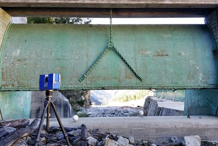
- High Definition Terrestrial Laser Scanning (HDS)
- Structural / Engineering Design
- Architectural
- Geological
- Historical Preservation
- Aerial Mapping and Orthophotography
- Independent Quality Control (QC) Surveys
- Contract Field Survey Support
- Contract Office Survey Support

Geospatial Services
Land Surveying Services
AEC Consulting Services
- Aerial LiDAR Data Acquisition
- Geographic Information Systems (GIS)
- Data Acquisition
- Data Intergration
- Database Design
- Data Visualization
- Digital Terrian Model (DTM)
- Building Information Modeling (BIM) Data Acquisition and Integration
- Project Scope and Specification Development Support

Land Surveying Services
Land Surveying Services
Land Surveying Services
- Topographic and Boundary Surveys
- Public Land (PLSS) Surveys
- Easement and Legal Descriptions
- Property Line Adjustments
- FEMA Elevation Certificates, LOMA, LOMR
- Geodetic Control Networks
- Monitoring / Deformation Surveys
- Construction Calculations and Staking
- Earthwork Volume Surveys and Calculations
About
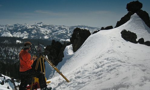
Mr. Farrauto has more than 25 years experience working in the private and public sectors as a land surveyor and geospatial professional. His diverse experience includes boundary and topographic design surveys, ALTA/ACSM surveys, construction staking for public works projects,terrestrial and aerial LiDAR data acquisition, High-Precision Geodetic Control Networks, Control Network design for aerial data acquisition, GPS processing and project planning.
Recent project applications include HDS scanning of sub-surface tunnels and airport baggage systems for design improvements, surface monitoring for subsidence, archeological artifact digital documentation for preservation, dam structural deformation scanning and facilities improvements, quantity analysis and slope deformation, and FEMA floodplain mapping.

Epoch Geospatial provides professional land surveying services throughout Oregon and California and can provide contract based survey support for your AEC companies' project throughout the Western United States.